
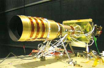
Thaichote the first Earth observation satellite of Thailand, was successfully launched by Dnepr launcher from Yasny, Russian Federation, on Wednesday, October 1, 2008 at 06:37:16 UTC (Universal Time Coordinated) or 13:37:16 hours, Bangkok Time.
Satellite Characteristic
| Launch mass | 715 kg. |
| Dimensions | 2.1 m. x 2.1 m. x 2.4 m. |
| Solar array | 840 Watt |
| Hydrazine | 82 kg. |
| Recording capacity | 51 Gbit (BOL) solid-state memory |
| Onboard image processing | 2.8 or 3.75 compression ratio (DCT) |
| Image telemetry | 120 Mbit/s (X band) |
| Attitude control | Earth pointing and high agility |
| Orbit determination | GPS |
| Payload | 1 PAN and 1 MS cameras |
| Orbit | Sun-synchronous (14+5/26 orbits per day) |
| Inclination | 98.7° |
| Altitude at equator | 822 km |
| Period | 101.4 min |
| Local equator crossing time | 10:00 am (Descending) |
| Sub-satellite point velocity | 6.6 km/s |
| Nominal life time | 5 years |
| Thaichote Sensors | 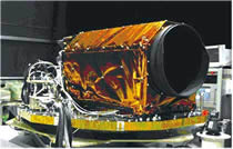 |
 |
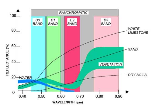
| Panchromatic | Multispectral | |
| Wavelength | P : 0.45 - 0.90 µm | B0 (blue) : 0.45 - 0.52 µm B1 (green) : 0.53 - 0.60 µm B2 (red) : 0.62 - 0.69 µm B3 (near infrared) : 0.77 - 0.90 µm |
| Resolution | 2 m. | 15 m. |
| Swath width | 22 km. (nadir) | 90 km. (nadir) |
| Number of pixels | 12,000 pixels | 6,000 pixels |
| Access corridor width | 1,000 km. | 1,100 km. |
|
|
||
Thaichote Image Capturing
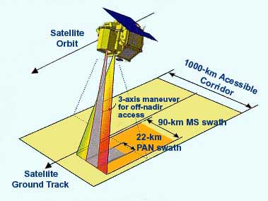 |
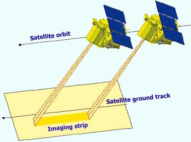
Nadir imaging
The PAN strip is 22 km width and theMS strip is about 90 km width at nadir. |
 |
Scene and strip imaging
Scenes are defined as a square portion of the imagedstrip. An image strip can be acquired continuously with a length of up to 10 minutes, which is an equivalent of approximately 4,000 km |
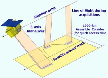 |
Repeat viewing capability
Thaichote oblique viewing capability allows for the imaging of any area within a 1000 kilometer swath (for 30° roll). Oblique viewing can be used to increasethe viewing frequency for a given point during a givencycle. The frequency varies with latitude: over Thailand, a given area can be imaged 9 times duringthe same 26-days orbital cycle. This means a yearly revisit of 126 times and an average of 3 days, with an interval ranging from a minimum of 1 day to a maximum of 5 days. |
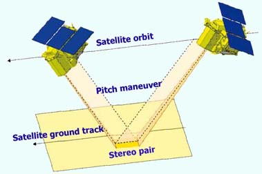 |
Stereo Imaging
Stereo pair can be used for relief perception and elevation plotting (Digital Elevation Modelling). Thesestereo images can be acquired by Thaichote with 2 different methods: |
Thaichote Products The Thaichote imagery product is available in a variety of product options. These product options use different spectral band combinations and imply differences in the pixel resolution of the final product.
|
Product Option
|
Black & White
|
Blue
|
Green
|
Red
|
Near Infrared
|
Resolution
|
| Panchromatic |
x
|
-
|
-
|
-
|
-
|
2 meter
|
| Multispectral |
-
|
x
|
x
|
x
|
x
|
15 meter
|
| Pan-Sharpened |
x
|
x
|
x
|
x
|
x
|
2 meter
|
|
Multispectral Products
|
Panchromatic Products
|
Pan-Sharpened Products
|
|
Thaichote multispectral products provide 15 meter resolution (at nadir) and 8 bits information depth. All four bands are delivered as one file. The output scene is a square scene of 90 km. x 90 km. |
Thaichote panchromatic products provide 2 meter resolution (at nadir) and 8 bits information depth. The output scene is a square scene of 22 km. x 22 km. . | Thaichote imagery products are also available in a 4-band pan-sharpened product option. These products combine the visual information of 4 multispectral bands (blue, green, red, Near IR), with the spatial information of the panchromatic band. Pan-Sharpened products are available as product option for level 2A only. The output scene is a square scene of 22 km. x 22 km. |
Corrective Levels Thaichote products are provided into two correction levels:
- System Corrected Level (1A)
Level 1A images are radiometrically corrected: in addition to level 0 pre-processing operation, the detector equalization and radiometric abnormality removal (missing lines, invalid detectors, and compression errors) are performed.
The PAN band and the MS reference band B1 are always geometrically raw.
Level 1A products are geo-referenced: it means that product annotations provide information about the image localization. (detail) - Geo-Corrected Level (2A)
Level 2A images are radiometrically corrected and geocoded, i.e. resampled on a cartographic grid.
Level 2A Imagery products are suitable for users requiring modest absolute accuracy and/or large area cov